
The “Panama Canal” of the East?
The Pinglu Canal & China’s New Southwestern Gateway
Redrawing the Map of Southeast Asia
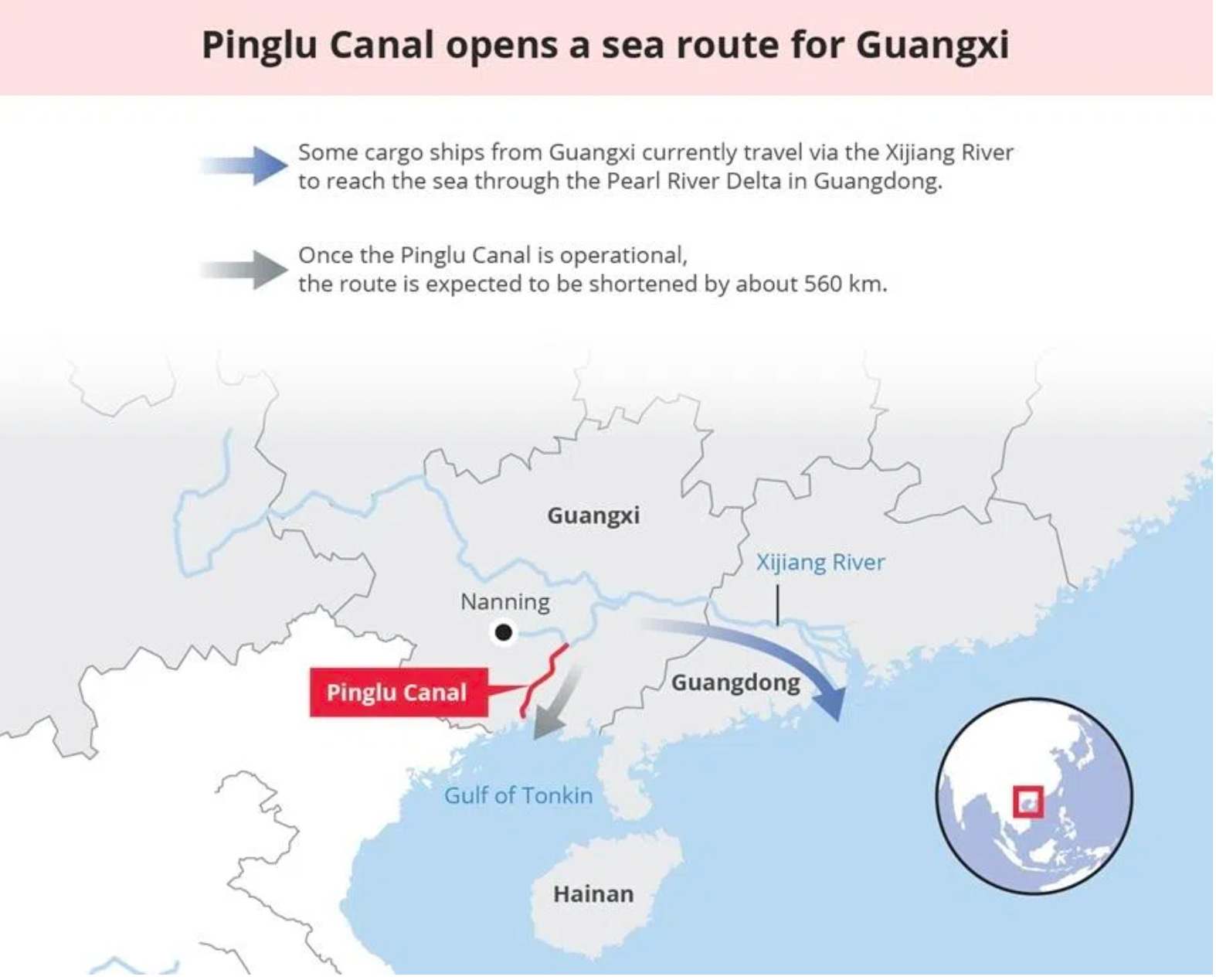
For decades, China’s southwestern provinces—Guizhou, Yunnan, and Sichuan—have faced a geographical paradox: they are “near the sea but have no access to it.” To reach international markets, goods had to travel over 500km east through the crowded waterways of the Pearl River Delta in Guangdong.
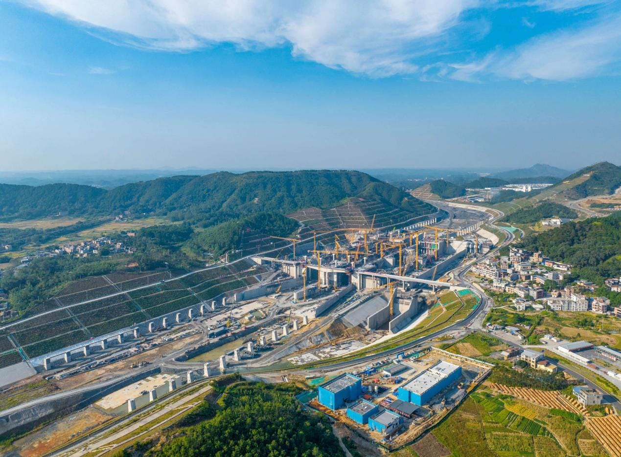
That is officially changing. The Pinglu Canal (平陆运河), the first major canal built in China since the founding of the PRC, is not just a ditch in the ground—it is a 134.2-kilometre structural realignment of Asia’s logistics.
As a backbone project of the New International Land-Sea Trade Corridor in western China, the canal links the Pingtang River estuary in Nanning, Guangxi Zhuang Autonomous Region, to the Beibu Gulf (北部湾, or Gulf of Tonkin) via the Qinjiang River. (See map below)
On 1 May, the Pinglu Canal project marked a historic transition as the cofferdam at the Qingnian Hub—the gateway nearest the sea—was officially demolished.
This critical step initiated flowing-water debugging, allowing engineers to test the waterway’s operational integrity under real-world conditions. By opening the gates to the tide, the project enters a high-stakes validation phase to ensure the ship locks and flow-control systems meet the rigorous standards required for China’s new southern artery.
The demolition signifies that the canal is no longer a construction site, but a living waterway preparing to connect the heart of Southwest China to the global ocean.
If you have an interest in China’s mega project, read this article too:
China starts building world’s biggest hydropower dam

China's Premier Li Qiang announced construction had begun on what will be the world's largest hydropower dam, on the eastern rim of the Tibetan Plateau on 21 July, at an estimated cost of at least $170 billion. What's this Yarlung Tsangpo hydropower dam? and why did China start building this dam?
The “Miracle” by the Numbers
While the Great Wall is a relic of the past, the Pinglu Canal is a testament to 21st-century civil engineering. To understand the scale of what is being achieved in the heart of Guangxi, consider these milestones:
Earthwork Titan: The project requires excavating 339 million cubic metres of earth and rock. To put that in perspective, that is roughly three times the volume of the Three Gorges Dam excavation.
The Water-Saving Giants: The canal features three massive inland ship locks—Maodao, Qishi, and Qingnian. The Maodao Hub is now the world’s largest water-saving ship lock, using a complex system of lateral basins to recycle over 60% of the water used during lockage.
Eco-Engineering: This isn’t a concrete scar. The project includes “fish highways” (dedicated bypasses for aquatic migration) and China’s first “Ecological Bridges” designed specifically for terrestrial wildlife to cross the canal safely. (This is insane and of course GREAT. Check the video below: A bridge just for animals)
The Strategic “Why”: More Than Just Shipping
Why spend an estimated 72.7 billion RMB on a canal?
1. The RCEP Accelerator
The Canal serves as the “backbone” of the New Western Land-Sea Corridor. With the RCEP (Regional Comprehensive Economic Partnership) now in full swing, the canal allows China’s industrial heartland to bypass the congested South China Sea routes and drop goods directly into the Beibu Gulf, headed for Singapore, Vietnam, and Indonesia.
2. Ending the “Guangdong Dependency”
Currently, Guangxi’s inland shipping is bottlenecked at the Changzhou Lock in the Pearl River system. The Pinglu Canal provides a direct “southward exit,” cutting the shipping distance to the sea by 560km. This reduces logistics costs by over 5.2 billion RMB annually.
3. Turning Nanning into a “Seaport”
Through the canal, Nanning—a city 200km inland—effectively becomes a coastal hub. This shift is expected to trigger a massive industrial migration from the oversaturated eastern seaboard to the lower-cost western provinces.
